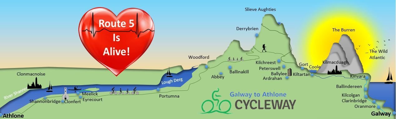


THE RIVER SHANNON: Shannon West
At the start of Route five, the river Shannon is the main feature. The ancient goddess Sinann was granddaughter of the sea god Lir. In her quest and desire to gain poetic skills, she went to the well of Segais. There she drowned in the river that issued forth, and the river bears her name. I’ve visited the well of Segais, the mythical source of the Shannon. A Salmon by miracle leapt from the deep pool when I arrived after my long journey north. This is also where the legendary salmon of knowledge dwelt…
At Shannonbridge the well-constructed bridge built in 1790 crosses the spectacular and stately river Shannon. During the Napoleonic period 1803 to 1815 fortifications were built close to this crossing and one of them can be seen on the West Bank to this day.
The main feature close to Shannonbridge is the large tract of bogland used by Bord na Mona until late in 2020 for extensive peat extraction. Now with a remit to restore all spent brown bog to peat bog, they plan to raise the water level to attract sphagnum moss growth. This wonderful moss, once used to dress war wounds, soaks up carbon too. I am sure I speak for many when I say the reappearance of fauna and flora will be very much welcome.
Leaving Shannonbridge behind we may notice how the riverside slopes at a shallow angle. It transforms itself into wet grasslands known as the Callows when the river floods. Dragonflies, butterflies and breeding waders such as northern lapwing, common redshank, Eurasian curlew and common sandpiper can be seen. All three types of swan are present, as are moorhens, swallows, terns and ducks. The corncrake lived in the Callows, taking advantage of the traditional hayfields prior to seasonal flooding. After the decline of the corncrake due to changes in both climate and farming practices, recent concerted efforts by the Irish government and national charities to restore this rare bird mean numbers are starting to turn around. That is in no small part due to their coordinated efforts. The corncrake is distinguished by its raspy call, akin to a muffled football rattle. I was fortunate to have heard it on my single visit to the Callows many years ago. I also have visited Tiree in the Inner Hebrides, where the corncrake thrives. I do hope that the successful return of this bird will delight many a discrete visitor.
As we continue along the river Shannon, it is well worth a small detour to visit Clonfert Cathedral inland. Clonfert Cathedral is only one of eight Protestant cathedrals in Ireland. Its Hibernian-Romanesque arch is highly decorative. Inside, there is a mermaid carving in the chancel. She is holding a mirror and a comb, similar to ancient Pictish symbols on Scottish standing stones. There are various interpretations of these unusual motifs. I muse that since this is the burial place of Saint Brendan the Navigator, could this be an apparition he had, immortalized in stone! The immram (saga) of St Brendan’s epic voyage tells of a blessed Eden-like isle he eventually reached.
Continuing to Portumna, the town may surprise us with its grand open streets and vernacular architecture. Portumna Castle is a grand monument that houses a heritage centre and also a reconstituted workhouse, the bane of Irish society from the 1840s until the 1920s. Now there is a lovely walled garden outside, supported by the local community. In addition, within the town a small nunnery has taken over an old domestic science school that used to prepare women for their household duties. An Gairdin supports the regreening the planet. Within their walled garden there is a small ecology centre that plays a key educational role and interface with the general public. Sr Noreen’s quote from a poem by Gerald Manley Hopkins sums up their hopeful ethos:
What would the world be, once bereft
Of wet and of wildness? Let them be left,
O let them be left, wildness and wet:
Long live the weeds and the wilderness yet
How fitting a sentiment for the whole greenway here! The Red Route Greenway now passes close to Shannon-fed waters of Lough Derg where the white-tipped sea eagle has been spotted. The species was reintroduced and made a comeback after a temporary glitch in the efforts. Anglers meanwhile are working to restocking the lake with trout and other species after numbers declined in the past. The Forest Park on the shores of Lough Derg hosts a wide variety of birds and trees. The greenway starts to rise as we enter the Slieve Aughtys, a wild mountainous region.
THE SLIEVE AUGHTY MOUNTAINS
In and around Woodford on the edge of the Slieve Aughties there was a tradition of charcoal-making in wood furnaces. Celebrated in their annual festival in August, the Furnace Festival resurrects the ancient art of iron smelting that relied on the presence of local iron ores. Incidentally there is a Heritage Centre in Woodford, which I still look forward to visiting.
Outside the town on the way to Ballinakill lies Commons East circle with just seven standing stones. There is a larger stone circle with unusual patterning above Ballina keel beyond Woodford. The Carton South Circle is a radial circle consisting of 19 stones, and has a lovely ash tree growing from it centre.
From a geological perspective the Slieve Aughties are predominantly made of Old Devonian sandstone. There also are mudstones and chert, a rock containing quartz particles. The area along the northern flanks is full of local archaeological finds, overseen in recent years by the ever-enthusiastic county archaeologist Dr Christie Cunniffe. Christie is popular and he won the National Heritage Hero Award in 2020. Over the years, he has helped identify many local finds, including the remains of temporary dwellings for fleeing clans. Catholics had been forced to flee persecution in the north of Ireland. In 1705 the Battle of the Diamon settled a desperate dispute over rights to work in the local linen industry in County Armagh. Cruelly driven out by the Protestant people “Peep O’ Day Boys, close to 7000 Catholics or Ultachs fled south to settle in places like the Slieve Aughtys. There they were forced onto the high grounds to eke out a living. They stayed on since then as evidenced in non-local surnames. Indeed the makeshift refugee camp is a reminder of one of Ireland’s largest internal migrations.
The Greenway follows the natural divide that the river Owendalulagh makes as it winds its way through the poorly drained mudstones and sandstones of South East Galway and North East Claire.
The river has a legendary tale that tells of the lack of fertility in these mountains. Princess Echtge who gave her name to these mountains was daughter of Nuada of the Silver Arm, a mighty De Danaan warrior reputed to be kind and generous. This was at a time when the invading race of De Danaan were taking over from the even more ancient Fir Bolg. In an attempt to preserve his vast lands that stretched to the Atlantic Ocean here, the Cup Bearer to his Fir Bolg king proposed to Echtga. She agreed and from her dowry of seventy cows Echtge placed a cow either side of the Owendalulagh river. One cow produced far more milk than the other, and so it was that they settled on the fertile side of the river, in the area now consisting of the Burren Lowlands and The Burren proper. Meanwhile, the more bleak and barren lands became known as the Slieve Aughtys. Being of the fairy blood herself, Echtge is said to have bestowed fertility on the barren limestone rocks of the Burren Hills.
Derrybrien means “oak wood of hospitality” and is set amid what was once a mighty oak forest. There is a well of incredibly good quality water beside the road opposite a drumlin in Derrybrien. (A drumlin is a rounded hillock of more fertile glacial soils left in the wake of a glacier passing.) The windmill farm at Derrybrien has been an ecological disaster but there is fresh hope that biodiversity will be restored. There is a lot of commonage that allows common pasturage of animals in these mountains. A mixture of farmland and bog is ideal for that rare bird of prey the Hen Harrier, whose habitat is encouraged by the Hen Harrier Project that spans several counties across the centre of Ireland. It is a successful conservation programme targeted at local level and aimed at “delivering sustainable benefits for biodiversity, upland ecosystems and a vibrant rural economy”.
As we descend the Slieve Aughtys a panoramic view opens up of the Burren Lowlands and then the adjoining Burren hills. Below us the rivers disappear in summer into swallow holes on the beds of disappearing lakes known as turloughs. The water levels shift, rather like the shifting sands of Arabia. Since the water courses are to some extent unpredictable, there can be a tense relationship with the elements if farming at particular locations.
As we pass Kilbeacanty, there is a new local initiative called the Abhainn Da Loilioch Woodland Group, which aims to enhance and protect native woodland species in the Coilte-owned Chevvy Chase. This wood is set within a beautiful valley carved by the Owendalulagh. As with so much of recent government planting, conifers were planted at the expense of native species that enrich the ecology more. Thanks to local voices, it appears things are now turning.
THE BURREN LOWLANDS
The woodlands around Lough Cutra support sika and roe deer and pine martens. A fine private castle stands at its southwest corner. The lake hosts at least seven small islands, some of which hold ancient orchards and the remains of early Christian cell churches (hermitages).
As the river enters Gort it changes its name to the Beagh River- close by the lovely Lough Cutra, named after a Tuatha de Danaan prince who fled Tara after losing battle. His brother is said to have fought the famous Ulster demi-god Cuchullain. This brother lost his battle too and lies buried in a nearby cairn in Kilbeacanty. Burial cairns and hidden dolmens (table-like structures over a burial site) are more dense in the Burren and its surrounding lowlands than elsewhere in Ireland.
It is widely believed that when the Tuatha De Danaan were losing their powers the race ventured underground and become the fairy folk. What better place to flee to than the Burren lowlands with its endless underground caves and rivers! It is also why Lady Gregory loved to collect the fairy stories in this area so full of stories of magical princes and more. W. B Yeats referenced many myths in his writings too.
The Gort River changes its name five times in its seaward course because it is frequently dipping below the surface as the soil on the limestone bedrock gives way to bare limestone fissures. Eventually the river merges with two other underground rivers to re-emerge as one deep river in Kiltartan, running only a short distance before disappearing into a cliff face…and then to emerge in the Burren Sanctuary turlough near Kinvara before once more dipping downwards until it re-emerges as bubbling springs in Kinvara Bay. The waterways follow a very complex system of flows following the geological fissures in the bedrock, and the whole area is vulnerable to sudden flooding if rainfall is consistently high.
The River Beagh passes by the ninth century Beagha Old Parish Church between Gort and Lough Cutra, raising the possibility of a pilgrimage route from the Aran Islands to Holy Island in Lough Derg. Local saints were constantly moving from one site to another. Early Christian saints settled in the Burren Lowlands in high numbers. For instance, at old Kilmacduagh, long associated with the Saint Mac Duagh, there were several satellite monastic settlements for members of his family who also took their vows. Long gone now, the forts in the region may have still have been peopled in these early centuries, and the saints may have depended on their own local benefactors. There was a cluster of seven small monastic cells in Seehaun, and several years ago in a hazel wood clearing I was able to trace at least three of them.
Mac Duagh was closely related to the generous chieftain King Guare of the Generous Arm, who had a castle in both Gort and Kinvara on the coast. The castle has long gone in Gort – but was situated on a silted island approximately opposite the garda station. In Kinvara, a castle has been built three times on various sites by the sea over the years. It is said that the first one had a white quartz base to it, and was known as the Gleaming White Castle. When a feast was held, King Guaire played a most generous host to one thousand bards from all over Ireland. It seems that the genes of the generous Nuada of the Silver Arm (father to the ancestral princess Echtge) are displayed in our local king Guaire.
It was Guaire who supported the construction of the first monastery at Kilmacduagh, and its round tower was designed and built by the Gobhan Sair, whose powers were magical. He resided at Ferns Abbey in County Wexford and in a dream an angel informed him how to erect a round tower, according to folktale. Kilmacduagh is the tallest round tower on the mainland of Ireland, with a door positioned 26 feet off the ground! Standing at over 111 feet tall, it is a true architectural wonder, seen leaning at five degrees from miles around. The conical roof was repaired in the 1970s and is a prime example of Irish ecclesiastical architecture. Although not as well-known as Clonmacnoise on the banks of the Shannon, it is nevertheless a gem. It overlooks the northeast corner of the Burren, an international geopark of limestone pavements and rocks measuring 250 square km.
Like many of the saints in the west, Mac Duagh spent time on the Aran Islands where he was a pupil at St Enda’s Monastery. The Aran Islands can be reached by boat from Doolin in the southwest Burren.
Gort deserves a page of its own, as it is the market town for the whole of the Burren Lowlands. There is a new river walk behind Aldi for locals and visitors alike to enjoy, and some great eateries. Gort is the Gateway to the Burren, positioned on a motorway route exit within view of the stunning Burren Hills and set firmly in the Burren Lowlands with its own quiet beauty.
Before continuing to Kinvara on the edge of the sea as well as a gateway to the Burren, we must visit Coole Park and Thor Ballylee close to Gort, where Lady Gregory and WB Yeats lived respectively.
The original house at Coole Park was demolished 60 or so years ago, but the stable block houses interesting exhibitions on both the wildlife of the estate and human history of the house. There is also a very good bistro restaurant. Coole Park is used widely and is managed by the National Parks and Wildlife Service. Refreshing avenues lead through the trees down to the edge Coole Turlough, a large disappearing lake belonging to a complex system of turloughs and disappearing rivers that form a significant geological feature in the Burren Lowlands. At one end of the turlough it is possible to cross to the adjoining nature reserve Garrylands only in the drier months of the year. Rare water violets grow in the fen-like grasslands beside the lake in early Summer. Horses can often be seen running wild along the far side of the turlough. This is a rare hinterland.
Thor Ballylee is a little further north and is one of the most beautiful and enigmatic spots to visit. Here in 1916 William Butler Yeats bought the old Norman-Hibernian style tower house that had been built in the fifteenth of sixteenth century. He had it restored and used it as his summer home and muse for 12 summers. Yeats 1865-1239 was a Irish poet and dramatist, prose writer and even Senator of the Irish Free State. He also won the Nobel Peace Prize in 1923 for
“for his always inspired poetry, which in a highly artistic form gives expression to the spirit of a whole nation”.
After leaving Gort, on the outskirts of Kinvara there is a private enterprise called The Burren Sanctuary. There, children can enjoy feeding the local animals, learning about native plants of the Burren of which there is a profusion, and play in the varied swing park. There is also a delightful path created around the area to visit the fairy village, view a turlough and many other small delights.
Once you reach Kinvara you have reached the next zone- the Wild Atlantic, only here in the sheltered harbour situation, the sea can appear quite calm.
THE ATLANTIC SEA: Galway South West Coast
If you are lucky you may spot a hooker in the harbour! “Hooker” is the name given to traditional boats built to carry peat over from Connemara to Kinvara as there is no peat in the Burren itself, since it is so rocky. If you have time to visit St Colman’s Retreat set under Eagle’s Rock nearby, you will have the opportunity to view the wild flowers which are in season between May and September. Often flowers grow together that originate in both Arctic and Alpine regions. They change from month to month and support a wide range of butterflies. The limestone pavement on the way to St Colman’s Cave is typical of the Burren Hills, and the rocks retain heat well so cattle are able to stay outside all year round. In fact, they are taken to the high grounds in Autumn in a reverse form of transhumance! The ground is up to two degrees warmer than inland so the growing season for herb-rich pasture is longer than elsewhere in Ireland. Farming is not intensive and a highly successful project called Burren Life supports farmers to retain patterns that support nature and good cattle- rearing practices.
There is also a large range of Burren Fairies to look out for! You may spot many on greetings cards and other products in the tourist shops in Kinvara, a brightly painted attractive village. Like in Gort, there are many traditional music sessions held at night time here.
En route to Kilcogan you pass by St Sourney’s Well and St Sourney’s Bush behind Drumacoo Church an early medieval site. St Sourney is said to have been a possible sister to Colman McDuagh the famous local saint.
The shallow sheltered coastal waters from Kilcogan onwards support the growth of extremely high class oysters. Harrods Store in London is arguably the world’s most luxurious store and it orders its oysters from the bay here. Two excellent local seafood restaurants are the Quay in Kinvara and Moran’s Oyster Cottage at the Weir in Kilcogan. At Clarinbridge there is usually an annual oyster festival held every September. Now they are preparing to open an Oyster Centre in their delightful village so watch out for this additional cultural gem!
Soon you will be in Oranmor, a small town close to Galway that has experienced new building estates around it, rather like Gort.
At this point I will leave you to enjoy in peace the many views of Galway Bay.
